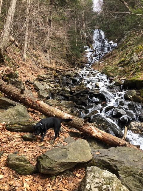
Money Brook Falls is always a spectacular site, but if you have to pick a season to visit: try spring.
Situated below Mount Greylock and spilling into the Hopper, the 80′ falls are a marvelous site thanks to snowmelt and spring rains ensuring there is plenty of water. There is also the bonus of the cold night temperatures maintaining the dramatic ice sculptures formed during the winter months along the perimeter and over fallen trees.
Accessed from the trailhead at the end of Hopper Road, the Money Brook Trail is the primary trail leading into the Hopper following Hopper Brook. Distance to the falls is a little more than 2.5 miles.
The trail veers to the left after the second bridge, and climbs through a stand of large hemlocks before descending and crossing the stream, which can be challenging when the water is running high.
The trail follows the stream and you climb gradually before descending again, down into a steep gorge where the trail takes you back up the opposite side and around to the falls.
The side trail to the falls is narrow, but it’s only a short distance further to the base of the falls where you can sit comfortably and absorb the setting before heading back.
It’s a fun hike that requires some effort over interesting and challenging terrain – take caution! – but the reward and feeling of accomplishment are priceless.

Distances: 3.1 miles to Wilbur Clearing lean-to, 3.3 miles to Appalachian Trail, 6.8 miles to Mt. Greylock summit
Difficulty: Moderate
Blazes: Blue
How to get there
From the intersection of Rts. 2 and 7 in Williamstown (the roundabout):
- Take Route 2 east to Route 43.
- Take Route 43 (Water St.) south to the Mt. Hope Park entrance (2.7 mi.).
- Turn left on Hopper Road. At a fork (4.1 mi.) bear left as blacktop gives way to dirt.
- At the end of the dirt road, use the designated parking on the right.
- There is an information board with a map of the Greylock Reservation and other information.
Description
Just east of the parking area (0.0 mi.), the trail begins at the entrance to an old farm road that once extended into the Hopper. Passing through a gate slightly further on, the trail continues along the road between maintained fields.
After the Hopper Trail diverges right, the Money Brook Trail continues to follow the wood road, coming out into a level field alongside Hopper Brook.
A short way beyond the end of the field, cross the Money Brook on the Bob Quay ‘04 memorial bridge. Follow the trail until it reaches a second bridge over Money Brook. About 100 feet beyond the bridge a cut-off marked with blue leads south to the Hopper Trail.
Leave the brook and ascend a hill to the right before descending to cross a small tributary, which may be dry in late summer. Just after crossing Money Brook (1.5 mi.), the Mt. Prospect Trail veers off to the left.
From here the Money Brook Trail follows the stream, but never crosses it. As you gradually gain elevation above the brook, cross a small tributary (2.2 mi.) to a steeper section, eventually making a sharp left (2.5 mi.).
A side trail continues 0.1 mi. straight to Money Brook Falls, a worthwhile diversion, especially in spring. The main trail climbs steeply out of the gorge, and you quickly lose the sound of the stream. At a level section, the Money Brook Cut-off leads 0.3 mi. east to Notch Road.
The Money Brook Trail continues through a stand of spruce, and passes a trail leading west to the Wilbur Clearing Lean-to (3.1 mi.).
Just beyond the shelter the Money Brook Trail terminates at an intersection with the Appalachian Trail (AT) (3.3 mi.). To the left the AT leads up Prospect Mountain, to the right are Notch Road and the AT route over Mts. Williams, Fitch, and Greylock.
Hike narrative adapted from the Williams Outing Club’s North Berkshire Outdoor Guide.